
Sidewalk Labs Launches API Layer for Urban Mobility
Sidewalk Labs announced the launch of a new spinoff company, Coord, that will be a connective tissue for street-related data, government, private companies, emerging mobility services, and the people who live in cities.
Coord is an API layer for transportation and a coordination platform for mobility services, navigation tools, and urban infrastructure. The company can help a ride-hail service make safer curbside drop-offs, help a navigation app show bike-share options, or help a car-share service give members a better sense of the true cost of their trip.
According to CEO Stephen Smyth, Coord "makes it easy for companies creating and offering digital navigation tools to integrate real-time information about new modes of transportation and to facilitate transactions. Coord provides software developers with access to APIs (basically, code that’s designed to be easy for other computer systems to talk to) for data on tolls, curbs, and parking in cities across the U.S., with more options like bike-share to come."
From the Coord website
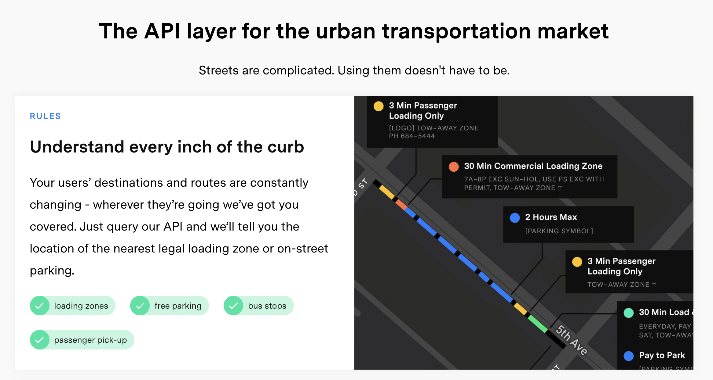
Current Problems with Urban Mobility Data:
- No real-time information about transportation options for consumers
- Issues coordinating and integrating emerging transportation services (bike share, rideshare, car share) with parking spots, loading zones, and the other types of transportation infrastructure
- Too many different owners of urban mobility data and very little incentive to share the data
- No standardized data set that can be used across cities by large mobility service providers
- Emerging mobility service data (e.g. bike share data) isn't currently available in navigation tools
- No true digital inventory that cities can use to manage their large networks of curbside assets (signs, hydrants, bike lanes, etc.)
How Coord Plans to Solve the Problem
Think of Coord as the connective tissue between large stores of data from cities and existing mobility services. Software developers will pay Coord a price to access data on parking, tolls, and curb space.
“Cities use data to regulate taxis, bike-share, TNCs, and signal lights, but each one of those is often kept separate. The need for a platform that can integrate that data is significant because the amount of data is, of course, greater than ever.”- Stephen Goldsmith, the Harvard Kennedy School
Right now, Coord provides three sources of data, on curbs, tollways, and parking. The Curb Search API provides data on the primary and permitted uses of curbsides in cities (think about all the businesses who waste hours finding loading zones). The Toll Search API gives data on how much drivers will pay to get to their destination so they can know the cost of every trip. The Parking API allows users to find parking in off-street lots and garages.
Coord has come up with an augmented reality tool called Surveyor, which lets users take a photo to digitize data about an entire block’s worth of curb space in just four minutes. According to Wired, the "company has already digitized the curbside—and the parking meters, parking signs, and curb stripes that live on them—in key commercial areas in New York, LA, San Francisco, and Seattle. That means cities, which often don’t quite know how many parking spots exist within their borders, can quickly access and reallocate those areas depending on need. A bike-sharing station here, a reserved car-sharing spot there."
A More Efficient Future
If all goes according to plan, Coord could provide cities with incredibly useful data that has the potential to benefit citizens and...
- reduce congestion by opening more parking spaces and diverting drivers to those spaces
- reduce taxpayer dollars spent on infrastructure maintenance and lend to more efficient project management for cities (instead of having a city employee sent out to keep track of curbside assets, these assets would be digitized)
- end transit surprises and snafus for city-dwellers (imagine data that could tell the MTA to add more trains when lanes on a bridge are closing)
- increase transparency in the planning process for city projects as planners begin to rely on new data sources
- reduce traffic (knowing true driving costs will nudge people to change their behavior)
And in addition to these immediately obvious efficiencies that come along with standardized, and accessible data, there will undoubtedly be countless new and unexpected use cases (and a concomitant boom in startups using that data).
By Charles LaCalle, Dreamit UrbanTech